
Nagsasa Cove Kayaking Adventure

Just like my previous successful outdoor adventures, I’ve spent some time planning and researching for it. Nagsasa was been in my wish lists of the places I want to see with my own two eyes. And a place to paddle too….
As a nature lover, photo-collector (dyahe sabihing photographer), camper and a kayaker, Nagsasa Cove perfectly fits all in. Let me share my stories…
No matter how hard and carefully you plan, there are really circumstances beyond your control. And for the cases like that, just leave it to God and He will do it for you. Me and my family went to Victory Liner terminal in Caloocan before midnight. Intendedly midnight to ride the last trip to San Antonio, Zambales. But to my surprise, there were a lot of passengers and all trips for that day was fully booked. It was school calendar ending and a lot of students going home. The queue was long even for the chance passengers. Since we were not able to get tickets, we decided to wait at the waiting area, for the first trip at dawn. Buses come and go, but still a lot of passengers at the departure area.
After maybe an hour there killing time, the dispatcher approached us. Asking where will be our destination. I told him, to Zambales but we were not able to get tickets. “Okay, I will help you get a bus.” Wow! We were so blessed. Thanks God, I never expected that.
We arrived at San Antonio past three am. Thanks to that kind-hearted dispatcher. If not for him, we were still there at the waiting area. The town was already alive at that early morning. A lot of local tourists, campers, mostly students and young professionals maybe.
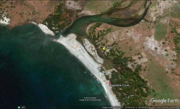
After buying our necessary supplies from the nearby market (only a couple of stalls has opened), we took a trike going to Pundaquit beach. The jump off beach for different destinations. It’s still dark, so we rested inside the cottage, probably owned by the boat owner whom we have contracted. When the day breaks, we’re off to the water. The boat was small. Maybe just enough for the four of us. But risky for the big waves. Since it is small, it took us more or less two hours traversing along the coasts. We reached Nagsasa at past 7:00 am. As part of the plan, I have already in mind an ideal place to camp. Every time I go to a tourist destination, I always wanted to be off the crowd. (read my blog about Caramoan adventure). Another criteria, I want near the body of water. But the owner (or care taker), was charging us higher than I expected. Part of my planning was reading blogs, written by those who have been to that particular place so I know the average charging.
We moved to other area. Inside the compound of the care taker. His name was Mang Eddie and Ate Celia. They have an enclosed t&b and supply of fresh water coming from the mountain. We set up our tent, and inflated my kayak and rest. The sun was high and scorching. After our lunch, each of us found our own space for siesta. Me and my two kids slept on sand, while my wife slept on her hammock which she haggled from a vendor at San Antonio.
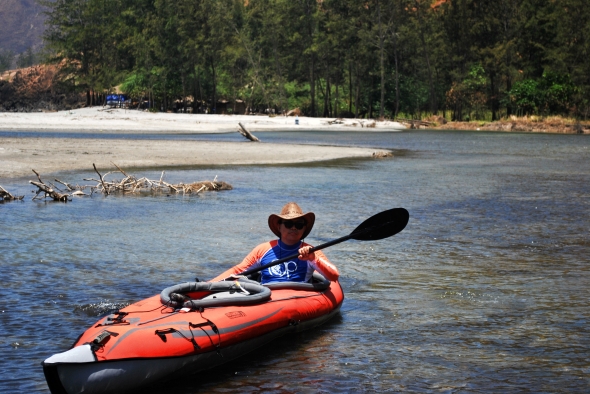
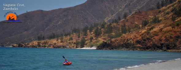
When the tide was high, I left my family still sleeping soundly. The sun was still high, but I thought to myself, I can’t explore the place when the tide goes low.
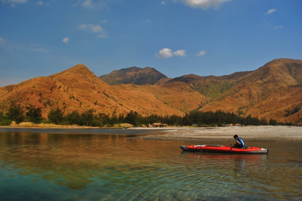
The feeling was overwhelming as I paddled along the creek. Before, I was only dreaming for this place. Envied the photos in the net. But now, I’m seeing it myself. Taking pictures myself. The color of the mountains was brownish. But it turns out green during rainy seasons. I think, this creek is being called by bloggers “the marlboro creek“. Because it is similar to the commercial of the said cigar. There are also agoho trees in the area, Which was started to grow only after the Mt. Pinatubo eruption in 1991.
When my wife woke up, we paddled there again and show her the place. When we got back to our camp, we were thirsty so we went to the sari-sari store by the beach. And bought the most expensive soft drink in my whole entire life hahaha. Seventy pesos lang naman ang 1.5 liter.
We stayed there by the beach for three days and 2 nights. Another dream come true. Another memorable adventure.
If you are a bonsai collector, you might be tempted to hunt some materials here.
I just can’t explain my feelings every time I see a view like this in reality.
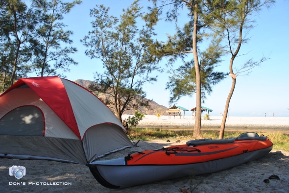
Our hotel and cruise ship 🙂
My son enjoying his moment
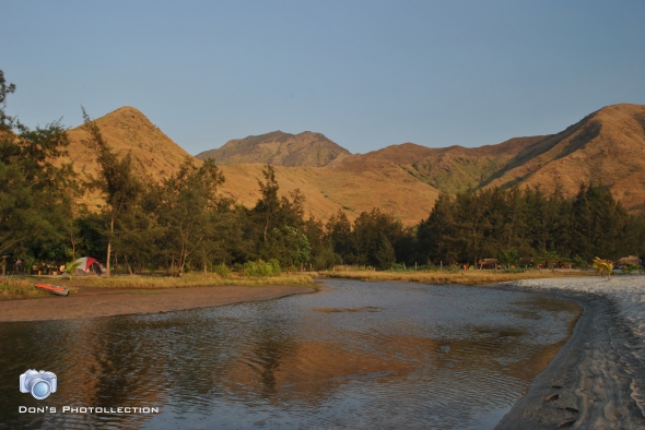
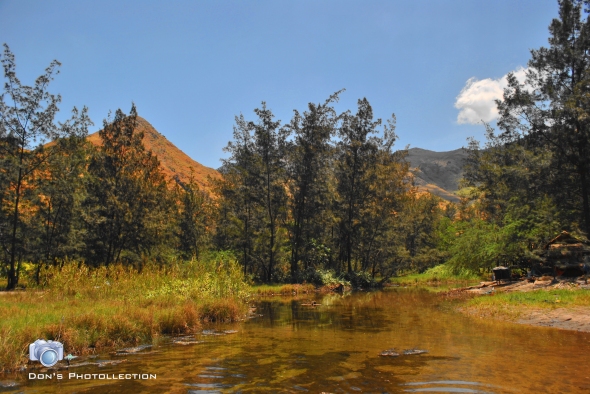
Creek near our camp
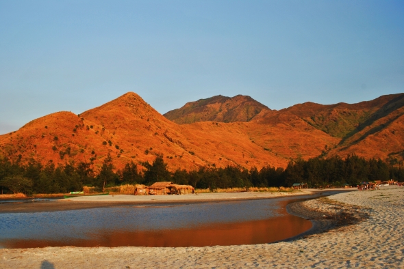
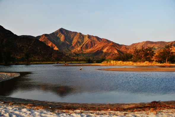
Color of the mountains during sunset


Biri Rock Formations Adventure
Biri Rock Formations was been dreamed/planned for almost a year after my Caramoan adventures in summer 2012. Just like Caramoan, it was a long and tiring trip even my point of origin was only from Sorsogon. But tiredness has gone, when I saw the place.

The Journey
A minimum of one hour bus ride from my hometown-Sorsogon City to Matnog, Sorsogon. Then another more than 1 hour trip in a ferry boat accros San Bernardino Strait (Matnog to Allen). Another 30-45 mins trike ride from Allen port to Lavesares; Another 1 hour boat trip from Lavesares to Biri Island; and lastly 15 min habal-habal ride from Poblacion Biri to Rock Formations. Just check some other blog entries if you are coming from other places like manila or southern samar.
Along the way when you ride habal-habal, you’ll stop in a tourism post for registration and pay entrance fee of 50 pesos. You will be given a flyer about the rock formations and the tourism rules and regulations. Camping was not allowed, but thanks God they allowed us by convincing them that we are responsible campers. Kayaking was not prohibited but (not mentioned in their flyer). The habal-habal drivers later told me that I was the first to bring kayak there. I’m not sure if they (tourism) were aware that inside our big duffle bag was a kayak.
It was low tide when we arrived. A little bit disappointed ‘coz we need to wade the water to reach the rock formations. After setting up my kayak, we started to wade our way to the rock formations. Our belongings were wrapped in a transparent plastic bags and tied in the kayak. But when we were at the middle between the formations and the shore, the water is only below knee level, so I decided to leave kayak behind. I just tied it between two rocks. We continue to wade our way. There are portions that the water is chest level. Watching my buddy clicking pictures as she find wer way in between rocks, I was worried my camera could submerge anytime if she lost her balance.
The explorers
We spent our morning exploring/shooting the area. We climbed the first rock formations named “Magasang”. It was easier to climb just like climbing the stairs of a stadium. It was a breath-taking view up there. I didn’t reach the peak, but it’s good enough to see other rock formations behind each other. you could also see from above the natural pools with crystal clear waters. The people swimming in the pool looks so tiny against the size of the pool. You could see the gigantic waves crushing agains the giant rocks. Watching open sea, wondering what kind of fish it could offer if I try to fish. Fishing was part of the plan before. But later realized that it’s not a good combination with photography and kayaking.
At noon time, we cooked our lunch under the canopy rock of Magsapad. First time to used my camping stove and It satisfied me. While cooking the rice, I decided to leave to take the kayak from where I left it. It was totally grounded by the low tide. I took first our belongings and returned back to take the kayak. More than 25 kilos plus a gusting wind that blows me sideways, took time to reach the rock. And need to carry it for extra meters ’cause my partner changed our camping area for lunch. She found an elevated area at eastern part of Magsapad. Luckily there was a group of teens that helped me carry the kayak. Thanks to them. After lunch, wasted no time, applied some sunblock and explored again the area. We climbed a big rock that the texture is similar to a lean concrete textured by the pouring rain. Yes it’s rough like that. I saw her capturing the big waves crushing from behind the rocks. Holding her month-old Samsung Note1 capturing the waves. I shouted at her, it might get wet. I joined her with my gopro. She sat at the edge waiting for the waves to crush behind her. With my gopro on, I videoed her having fun with the waves. But I was worried, one big wave could swallow her and take her to the open sea. We walked from Magsapad to Macadlaw. Along the way capturing, videoing anything that interests us. Macadlaw is a rock island with two coconut trees and vegetations on her top. I also noticed a fossil-like giant set of teeth. Thinking, what might archaeologist might explain about it. There is a perfect spot up there for camwhores. A rock near the cliff, almost cantilevered from the main rock island. If you’re on top, you could see the other nearby rock formations. Our kayak and our camp was not visible anymore from Macalaw. But Magsapad itself on west side is visible. On eastern side, it could be “Bel-at”, “Caranas” or whatever. Macadlaw is also ideal as camp site, but we were thinking of moving back to Magasang so that it’s near where were dropped by the habal-habal drivers. My Gopro’s battery ran out. Sad to say that I lost my chance of shooting underwater. I’ve had enough memories, but not enough energy.
Before sunset, we decided to transfer our camp at Magasang to spend our night there. We carried all our belongings (again) from Magsapad to Magasang. If it’s only high tide, I don’t need to carry them all including the kayak. I could have just paddled to trasnfer. It’s good that there is a plain surface at Magasang. Very ideal for setting up our tent. Maybe only two meters above the water level. Even the kayak, we ‘parked’ near our tent anticipating the hightide at night. We finished off the day with a light dinner.
Inside the tent was, was hot. Oh no, it’s not what you are thinking. It’s literally hot. Though it’s windy outside, it bounce off the rock wall behind our tent. I was thinking of getting out the tent and sleep outside. Woke up early morning to catch the sunset. And had photographed our basecamp. After breakfast, we swam and snorkeled at natural pool. there were fishes under. I was thinking to fish last night but my foot aches and got blisters. My aqua shoes was comfortable at first, but got blisters and wounded later. When the tide was high enough for paddling, we packed up our things and paddled in between mangrooves. If it was only high tide yesterday when we arrived, we could have seen the other rock formations. We paddled back, planned to dock at the foot of the stairs of the viewing deck opposite to Magasang. But when we were there, I found it difficult to hold still. The current was strong. So decided to land on shore instead. We saw two habal-habal arrived. We thought that they are our drivers yesterday. And we were right. They said, they thought they might not received our text when we will be picked up because the signal of globe in the island is poor. (but we’re using smart). I paddled a few more before I docked from were we started yesterday. We deflated our kayak and packed inside the bag and go.
There is a public bathroom at poblacion where you could wash away the sea water in your body. there is no fixed rate, only donation. There was no scheduled trip to Lavesares. The boat also bound to Matnog left early morning around 7 am. So we decided to proceed to Bgy. Sto. Nino, as suggested by our habal-habal drivers. Luckily, there was a boat there to Lavesares. But we waited for a few more passengers. After waiting for more than hour, we’re off to go. Goodbye Biri, hoping to come back someday to see other rock formations.

Me and my kayak at the port of Allen.

Ready to explore

Pulling instead of riding it because it’s low tide.

Magasang , the furthest rock formation.

From the top of Magasang, you could see Macadlaw and a natural pool below.

Rock formation far ahead is Magsapad. It has two cocounut trees on its top. It’s ideal also for camping because the rock is covered with grass.

Giant waves coming from pacific

Paddling in the waters of Biri.

Another natural pool behind magsapad rock formations

Good morning Biri….

Our camp site

looks like frozen waves.

Children of Biri are so lucky. Having a crystal-clear water to play into. The waterfront of Poblacion.

While we were at Bgy. Santo Nino, waiting for the boat to leave. This old woman catched our attention. She’s from the nearby island, crossed the sea to fetch some water from a deep well. She made several trips carrying a pail on each of her hands, and transferred the water to those containers.
Adventure in Bulusan Lake
Waking up early was not a routine of my son Cymon and my daughter Axl. But this morning was different ’cause they are coming with me. Destination: Bulusan Lake. Dubbed as the “Switzerland of the Orient”.
Boarded a jeep at the terminal near the Sorsogon Cathedral (Sts. Peter and Paul Cathedral) to Irosin because there is no direct trip to Bulusan. It’s good that the jeepney left the terminal even we were only three adults and three children. But the jeep gets full by picking up passengers along the route. When we were at Irosin, there we feel bored while waiting for the jeep (to Bulusan) to get full of passengers. We waited I think thirty minutes. The driver of the jeep didn’t showed up until his jeepney was full. Along the way, there were still passengers being picked up and hopped in, even clinging and standing at the steps of the jeep. In the city, you could rarely see female hanging on the jeepney. But here in remote area, male, female, old or even young students have no choice ’cause there is only few jeep plying that route. And TAKE NOTE: the last trip back to Irosin is 3pm. I was sitting beside my kids (I paid their sits). On my lap was my back pack. One woman offered, or requested to hold Axl on her lap. When we approached the road under construction (very rough road) I noticed Axl’s face was so pale. I thought she feels dizzy because of zigzagging and bouncing ride. When there was an empty sit, Axl took it. I was worried she might vomit. But she didn’t. Later When I asked her what she feels on that woman’s lap, she said the woman was holding her so tightly on her tummy.
When we arrived at Bulusan proper, I just bought two liters of mineral water then hired a tricycle to take us to the lake. Actually, the jeep we rode passed by the entrance going to the lake. But we didn’t dropped by there because the lake was 2.5km from the hi-way and there were no tricycle at the entrance going in. We agreed to the amount of 150 pesos for taking us there. He tied my inflatable kayak at the roof of his trike. There was no chance of taking pictures along the way because of the road condition.
Bulusan lake was now different compared to ten years ago when I first saw it. It is now frequently visited by tourists often by the family of OFW’s. There are now kayaks for rent. The entrance fee at the lake is only ten pesos. While the rental for kayak is 200 pesos per hour (or was it per half our?). I asked the fee collector, if it’s okay if I use my own kayak. He didn’t got what I mean so I explained to him that we brought with us an inflatable kayak. Pointed to him the duffle bag beside my son. He explained to me that it’s okay but they will not be responsible if something happens to us in the lake. And I said I understood, and added that we brought our own PFD (personal floating device or life jackets). He asked a few more questions regarding my kayak. How much I purchased it, how and where etc. I think I was the first visitor who brought along kayak.
We took some souvenir photos and had our lunch. I prepared adobong manok as our baun. We were allowed to eat under the canopies of the trees at the foot of Virgin Mary grotto. After our lunch I started to inflate my Advanced Element kayak at the edge of the lake. As I was pumping the air, a man on his shorts, wearing t-shirt and a hat (similar to those scout rangers), and with a radio hanging on his hips approached us. “Sorry Sir pero next time wag na kayong magdadala niyan ha.” I was speechless to what I’ve heard. I just nodded voluntarily. But in my mind, i have a lot of scrambled words that I wished I could tell to this man. I want to tell him “you don’t want to bring us a kayak because you have kayaks for rent.” But instead, I continue inflating my boat. We need to hurry because we need to catch up the last trip going back to Irosin.
So there we are paddling in the Lake of Bulusan. Axl was in front, while Cymon in the middle. I paddled slowly towards the east. There were two motor boats at the lake. One was carrying a group of tourists, the other serves as a back-up. I snapped some photos from time to time. Finally we reached the other side of the lake. There was a pergola there. There is a hiking trail around the lake which I think I might try next time I come back without a kayak. After paddling and taking photos for an hour, we decided to go. There are no closed cottages by the lake but they allow campers overnight at the parking area. After I deflated the boat, we off to go. Unfortunately, we need to walk out of the lake area. No tricycles available. I told my kids, “it’s really more fun in the Philippines, but this is not funny anymore.” (Walking 2.5km with a back pack and a duffle bag on my shoulder.) My perspiration was dripping.
We waited at the highway for more than hour before the last jeep came. There was a resort beside the main entrance of the lake but there was no available room for overnight. The caretaker said, she still needs to clean it ’cause the owner had just left last night. If there was only a vacant room, we could spend our night there. Hoping, that would be available rooms next time….

The lake

kids enjoying the boat ride

@ the other side of the lake (east side).

for rent

the lake

@ Irosin, waiting for the jeep to Bulusan.

Having our lunch at the foot of the grotto.

Getting ready

Out of the lake…

Next destination???

Resort near the main entrance of the lake

- Bonus picture: the Bulusan volcano taken by my son from the jeepney.

MY DIY CARAMOAN KAYAK ADVENTURE
THE JOURNEY
It was already been my dream to see Caramoan with my own two eyes even before the Survivor reality show made it famous. I first saw the pictures of it since I discovered Google Earth. Since then, I became obsessed to see it. Being a nature lover, I didn’t worry of the perils might be in going to that isolated place of bicolandia (alone). I asked my ten years old son if he wants to come, he said he is afraid to ride in a boat.
April 28, 2012, it was past six in the morning when the Queen bus line left Sorsogon. One hour passed, and I was there in Daraga, Albay waiting for a bus to Naga. At past 7am, I boarded Ibea bus line bounded to Manila. But most of the passengers were only as far as Naga City. And the bus was frequently stopping, picking up passengers. I was sure to myself that I will reach Pili, Camarines Sur by noon. Will surely be missing Raymond Bus from Manila bounded directly to Caramoan.
As I was expected, it was almost 12 noon when I dropped at the crossing of Anayan Pili. I boarded again a bus (JC Liner) and dropped at central terminal of Goa, Camarines Sur. From there, I boarded a jeep bound to Sabang. Upon reaching Sabang, porters calls for passengers going to Caramoan. I let the porter carry my duffle bag (my inflatable kayak) to the waiting area at the beach. There were already passengers waiting for the 2 pm trip. Some of them, a group of Taiwanese tourists. A big passenger boat was anchored a few distance from the shore. But it left for unknown reason. And later before 2pm, it was announced that the boat was not able to cruise. So the passengers will be divided in two smaller boats waiting by the river of Sabang behind the wet market.

This is the boat supposedly will take us to Caramoan
It took two and a half hours to reach Guijalo port in Caramoan with that boat. And it was already 4:30 pm. I asked one tricycle driver who has a passenger, if I could join the ride going to sentro ng Caramoan. Thanks God he agreed together with two other passengers. The sceneries along the way to Caramoan proper was nice but was not able to grab may camera ‘coz my right hand was gripping the hand bar (I was at the back of the driver) and the other hand was holding my back pack. But the road was far better than my tricycle ride from Bulusan proper to Bulusan Lake.
I bought three liters of mineral water, 2 cans of sardines, 2 instant noodles and worth ten pesos of bread. I didn’t starved much because I bought puto (rice cake) and baduya (fried banana) on my bus ride. It was getting dark already when I decided to proceed to the beach. I asked the tricycle drivers if how much if they will take me to Paniman Beach. They said, since it’s getting dark already, and will be no more passengers going back, they will charge 150 pesos. But they are not greedy ‘coz they suggested me to take habal-habal (single motorcycle) instead. So I rented two habal-habal. One for my self and one for my duffle bag. Fifty pesos each, so I saved fifty pesos. We let the motorcycle with my bag to lead the way so that we could keep an eye with my bag if it’s about to fall. It’s already dark when I set my foot at Paniman beach. I found myself just in front of Breezes and Waves Resort. But since I don’t have a plan to check in a hotel, I asked the caretaker if I could set up a tent there at the beach. The old man was very kind to me. And he assured me that nobody will harm me if I wished to camp there. So I started setting up my ‘hotel’. I brought a sleeping bag with me but it’s too hot to sleep in it. So I just used it as my sleeping mat.

Just camped in front of a resort to spend the first night.
I woke up early morning. My sleep was not as comfortable as sleeping at home but I could say “I survived the night”. I used my handmade camping stove (out of tin can) to boil water for my coffee. Which I partnered with the bread I bought from sentro yesterday. After breakfast, I started to prepare my first day exploration. The caretaker stayed around and watched me inflated my kayak. When everything was set, he assisted me putting my boat in the water. Caramoan here I come!!
I have printed copy of google map inside my duffle bag, but didn’t took it out ‘coz I already familiarized it. I asked the old man if that island we saw from a distance is Matukad, and he said yes. My orientation was correct hehe.

I passed by this rock on my way to Matukad Island
My first aimed Island was Matukad but did not paddle directly there. I paddled in between islets, literally exploring the place. Thanks God the water was calm and crystal clear. I constantly checking the depth of the water, not getting in too shallow where there might be protruding sharp rocks that could rip off my boat. I placed my snorkel set in front of me ready to grab just in case my kayak capsized. I also wrapped my camera in a plastic bag and placed it behind me, taking it out from time to time to capture the view. It’s a wonderful place and you could really appreciate how great God is, by His creations. Since it is still early, there are less sounds of bancas in the area. It’s so peaceful out there.
I reached Matukad Island before 7 am. And feeling proud that I was the first visitor on that day. There were no traces of footprints at the beach, except on higher grounds where had not reached by the waves during high tide. I tied my boat on a rock and submerged myself on its water. So refreshing…..
After a few minutes of snorkeling in the area, I climbed the huge boulder. It looks like a puzzle rock, stacked on top of each other that forms one boulder. The view on top was breath taking. You could see how clear the water is. On the eastern part from where I was standing, I could see the beach of Lahus Island (as per my familiarization of the place via Google Earth). A few minutes later, here comes the visitors. First boat….. second boat. A visitor from manila approached and asked if he could have a picture of himself with my kayak. In return, I asked him to snap me too. (I didn’t bring a tripod). . I left the island before the third boat came. (I shall return.)
LAHUS ISLAND
Next stop over is Lahus or Naglahus Island. Some call it Bichara Island. It’s an island with two beach fronts (east and west side). And luckily again, I was the first visitor of the day. I anchored my boat and took some pictures of the island. The rocks of Lahus are very sharp.
I was also surveying for a good place to camp when the night comes. And there was an ideal place. And I told myself, I shall return…. A few minutes later, the first motorized boat arrived. I chit-chat with the bankero. He said they came straight from Guijalo port, and his visitor will pay him 2,500 for the island hopping. I have seen them yesterday at the waiting shed. One female, and two male. And I think they were siblings. I asked the bangkero if he knows where Tinago Cove is, and he said it’s too far from here. I said no, it’s just somewhere here. I didn’t argue with him because I am sure with myself. I’ve planned and researched for this trip for years. Maybe he was referring to different ‘tinago’ because he came from Guijalo. I joked to myself, how could I found it if is hidden. And he offered his services, “if you want, I could tow you going there….” Oh really… how nice of you…. But thanks anyway, what is the used of my paddle if you will tow me.

An island with two beach front. I’ve been dreaming for years to see this island.
TINAGO
Tinago, tinago, sino ang nagtago? I paddled toward south-east near the coast line. If you are far from the coastline, you will not notice that there are islets and coves before the shore or coast. I found a passage in between two huge rocks. I slowly paddled in, stop, look, and listen…. (paran tren lang ano.) And then I saw a short strip of white line. A small beach. I continued paddling in until I saw an opening channel on my left. Voila!! This is it. I found the Tinago. As I get nearer to the beach, I smell something like a cologne. Does God sprayed cologne on this place? I asked myself. Maybe it’s a fragrance from the wild flowers in the area. Once on the beach, I texted someone (yes there was signal on cp). “ I found Tinago. But I would like to call this “paradise”. The color and texture of the sand is like washed sugar. One thing that saddened me was the traces of bonfire right at the foot of a tree. The tree is already dying. Irresponsible campers are destroying the place. There were also empty cans of beers. It’s a good thing that bangkeros were the one collecting the garbage of their clients. I asked one bangkero who arrived later to take my empty can of sardines.

I call this place “Paradise”
I was about to snorkel when I heard the sound of a motor boat. Alone no more! So instead, I cooked my lunch even if it’s still past 10 am I think. I’ve positioned my DIY camping stove between the crevice. Then more boats came. They even had pictorials with my kayak. After I had my lunch, I decided to leave the place because it’s getting crowded already. Although there were beautiful girls on their swimsuits, some kababayans and some foreigners, I didn’t dare to take snap on them. I might get in trouble.
So I traced my way out of the cove. But stopped in the middle to take some pictures of the cove before returning to open water. Tracing the coastlines eastward. My next quest was to find the Tayak Lake. I did found the beach that serves as the entrance to hidden lake. But before I reached the shoreline I was met by a shirtless man with a hand held radio and a jungle bolo on his side. He said they will not allowed visitors to get in because Suvivor will shoot. I know he was lying because the caretaker of the resort where I camped told me that the cast of survivors are on 10-day vacation. Bu I did not insists. Frustrated, I turned away and paddled back to Lahus Island where I spent my siyesta and watched the tourists came and go. I was surprised by the volume of visitors on that island alone. Sometimes three were twelve bancas docked at the same time. Squeezing each other on the beach. I talked with bankeros while waiting for their passengers. We where there at the foot of the rocks hiding from the sun. They said, the rental of the boat ranging from 2, 500 to 3,500 pesos depending on the number of passengers and depending on how many islands they will visit. Some tourists hired tour guides so that will be an additional expenses. If you’re about to go, you could save by not hiring a tour guide because boat men themselves knows the place and they will be your tour guides. However these boatmen don’t have access to internet so you can’t book or negotiate with them prior to your trip.
When I feel bored watching the people on the island, I decided to leave and headed back to Matukad Island. I found more interesting views of the island. On the east side of the island, there was a huge rock that looks like it was placed on top of rocks. Just like a canopy. I paddled to the other side of the island looking for the small beach that I remembered from google map. I found it but it was creepy. I mean I feel being enchanted. I was there floating on the water for more than an hour figuring out how to get to the beach without being slammed by the rocks by the waves. I could see the beach behind the tower rock that seems like guarding the beach. This rock has holes that serves as nests to birds. I really want to get to that beach but was afraid, my boat could be ripped off by the sharp rocks. I wish I have a company with me to take care of my kayak so that I could snorkel in between those rocks to the beach. Ant that is the thought of coming back some time. Would you dare coming with me? 🙂

It feels like some eyes are watching me…

My kayak on matukad island

View from the top of a rock in Matukad island

Lahus Island

Tinago Cove

While on search for Tinago Cove

Behind this beach is the Tayak Lake. Unfortunately I was not allowed to get in by the guard.

My first morning in Caramoan

My kayak

My DIY camping stove

My kayak, deflated
Rompeolas Memories
I didn’t know that the correct name of our town’s port is Rompeolas until the cyber era came. We used to call it “Rimpyolas” before. Anyways, Rompeolas nowadays is very appealing. It is now a constant destination to locals aside from the Capitol Park. A good choice for the joggers and brisk walkers. In the previous administration, the local leader beautify it by adding an area for gazebos and a bay walk. Later, the new official added a break water. This break water was not yet finished when I took my vacation in the summer of 2010. With this break water, I think it will be a good place for boating or kayaking inside the ‘mini-marina’. In fact I saw a bamboo raft (balsa) when I went there.

Rompeolas at night, taken from the break water.
The two major commodities being docked on that port are beer and cement.

Rompeolas before sunrise, taken from the break water.
In the 80’s, it was used as the dump site of Sorsogon (municipal at that time). There were also lot of squatters near the dump site. There were no lights along the stretch of the pier. But because of that, it was a good dating place for lovers including me. Me and my barkada together with our partners caught dating there by our kuyas during simbang gabi. Instead of attending the mass at Sts. Peter and Paul Cathedral, we were there at Rompeolas having our “simbang tabi”. (My wife doesn’t know this story so please don’t tell her. Or else there will be an interroagation . hehehe)
We also used to fish there with “tapon-tapon” style. Instead of using a rod, it was just a nylon rolled to the can of sardines or to a piece of bamboo. But the catch was not inspiring. Kadalasan parangan lang ang nahuhuli. There was also a time that me together with the boy from the neighborhood (a name of Nimrod Plantado) went there to fish. We climbed into one of the out rigger boat (baroto) which was tied at the pier. When the owner of the boat came, he was mad at us for intruding in his boat. He untied the boat from the pier and let the boat float in the middle of the water.
But I know that it will not take us far ‘coz it was still anchored. But the boy with me was panicking already. Since I already know how to swim, I took him back at the pier when the owner left again.
But there was a night that my father took me there and we fished together. There was not big catch but it was one of the best bonding moments with him.

Rompeolas @ sunrise

Rompeolas viewed from the bell tower of Sts. Peter & Paul Cathedral
The Original Chatters of Batha
The Original Chatters.
Eid 2011, Riyadh, Saudi Arabia. It was the first day of a
week long holiday in Saudi Arabia when I went to Batha (City
Center of Riyadh). My mission is to buy my long dreamed
flash (sb-700) for my camera so that I could use it on this
holiday, and to buy a black cloth for my planned room
studio. I dropped by at indian community just next to
filipino community. It’s because stores at Filipino
community area are mostly electronics and gadgets. There was
still daylight when I got there. As I am searching for the
cloth on every textile stores, I’ve noticed that the crowd
in every corner gets thicker and thicker. When Sallah
(prayer time) was shouted on loud speakers of minarets, I
stood at the sidewalk just behind the vendors. The area at
this moment were already filled with indians, pakistans and
Bangaladesh. You could distinguish them by their attires.
Pakistanis wore ther traditional dress (similar to pajamas,
except it’s only plain color.) though Bangladesh and indians are
identical, some Bangladesh wore clothes with embroidery.
When sallah was finished, I walked deeper into the crowds.
It is now like divisoria during christmas season. But in
Divisoria, most of the people were shoppers while these
indians and pakistanis are only standing and chatting with
each others. Even on ordinary weekends, they just go there
to meet and chat with their countrymen. There were 2 to 5
persons averagely on every group who were talking to each
other. The place were filled with voices which you cannot
even pick up a single word. But the smells were
recognizable. Common smells were body odors and “nganga”.
Since I need to squeeze myself in between them, I could
smell myself like them too. It was attached to my shirt.
Finally, I’ve found what I’m looking for, for 15 riyals per
meter I took two meters. Going back to my previous path was
harder than going thru the other end of the block. After
fiften years since saw this community (Batha), almost
nothing has changed except some new bldgs. But the crowds of
chatters had not changed.
Pinaculan and the Sea Shore of Bitan-o

Pinaculan island as seen from Rompeolas
Pinaculan is a tiny island situated between the Rompeolas and the shore of Bitan-o. It was an idle land some years ago. But my mother once told me that there was an observation structure there. It was one of my option for my thesis proposal before I graduated from college. The island is very interesting for a site development planning and design proposal for architectural students. During my elementary years, we used to gather from there boulders and sand to patch into the holes of the pathway going to our school-Bitan-o Elementary School.

Foot bridge to Pinaculan Island

The suba of Bitan-o

Two decades had passed since I last stepped foot in the island, I discovered that it is not an idle land anymore. I revisited it last February 2011, and found out that there are more or less twenty households occupies the islet. Though they are illegal settlers, they had made the land productive. If it was full of cogon before, now it is like a banana plantation. There are bananas everywhere. I’ve spotted also a pili tree, coconut trees and some pineapple plants. One house I passed by has a backyard pig pen. I just followed the trail, and it brought me to the other side of the island. On the east side facing Rompeolas and the new break water.
Though Bacon Beach has a very nice water to plunge in, there were times that we swim at Bitan-o. Just a walking distance from our house and will not cost you a single centavo. When the moon is big, it means the tide is high and is good for swimming. And when the tide is low, it is good to gather some tagunhas (sea shells). We usually went there before the sun rise.

The fisher folks of Pinaculan island

This is the area where we collect tagunhas (sea shells) when we were kids.

- Pili tree in the island

Rompeolas as seen from the east side of Pinaculan


Fresh water well in the island

A young beach comber found a coconut.
When the Sorsogon Bay was not yet contaminated by red tide, we frequently went there to collect sea shells. Punaw, kagot, barisara, piyong, talaba and kasag are the common take home. Sometimes you could find baluko and badoy too. Talaba (oister) could be sometimes un-noticed because it is attached to a rock. And you thought it’s just a rock. Sometimes I cracked a shell of talaba and eat the content right there. It’s very tasty. You could find also crab or tambagoy (talimusak in tagalog) underneath the rock if you upturned it.
Now that red tide is not being raised down, and the coast line of Bitan-o is being occupied by migrated residents, you couldn’t see people combing the shore line of Bitan-o and Cambulaga (adjacent baranggay) even if the tide is low. A beach combing which my children’s generation might never experience.
Joyride in Angono, Rizal
November 2007 to April 2008, me and my family temporarily living in Antipolo. Actually the place i s already part of Angono. Don’t know why they (residents) prefered to be called residents of Antipolo. My brother in law lend me his motor bike to be used as my service going to and from Antipolo proper. Eager to explore the place, I drove opposite to my usual route. With a GPS map installed in my mind, memorized from google map on a previous night.
I was impressed by a breath taking views that greeted me when I got out of that subdivision. It was a straight road going down and up. I asked permission from the guard of one subdivision if I could take some pictures of the view from inside. But he didn’t let me in. Before going down on a zigzag road, there was a spot where you could clearly see the laguna de bay.
Photos below are the shots taken from my nikon cool pix. (nikonian ever since.)


Behind me is Laguna de bay

Cement factory

Trees by the road

this is the best spot over looking Laguna de Bay

Dangerous cliff
